Allegany State Park – Scenic Journey
NOTE … A permit is required to place this cache in Allegany State Park. Call to get the form.
WATER
THANK YOU Earth Mother for your life-sustaining waters.
The depth of a soul is not measured by what appears on the surface.

EARTHCACHE REQUIREMENTS
Each cacher must send his/her own answers to log a find. … “Geocachers must complete the tasks before they log the EarthCache as found.” (4.3. EarthCache logging tasks)
Enjoy the journey (learning adventure) as well as the destination (smiley earned). Remember to take only pictures and leave only footprints. To get credit for this Earthcache, complete the following tasks:
NOTE: Posted coordinates are near ASP entrance. You are welcome to visit waypoints in any order you choose. All coordinates are taken from the center of the bridge. There is parking before/after each bridge. Be Safe / Have Fun!
NOTE: Answers via message -and- log signature picture are required to post a find for this cache.
Choose 10 of the 14 numbered waypoints. Make the following observations for each of the 10 you selected. …
a. MESSAGE …. What is the location? If the site is unnamed, then create one using the observable features. Example – If you are on an iron bridge overlooking a stream, your location might be Iron Stream.
b. MESSAGE …. Describe one feature you observe. This can be about the bed/banks and/or the effect of the flowing water on the bed/banks.
c. MESSAGE …. What method (if any) is used to prevent riparian erosion?
11a. MESSAGE RIDDLE …. At which waypoint can the water be heard, but not seen? Explain.
11b. MESSAGE RIDDLE …. At which waypoint could only Bigfoot cross without getting his feet wet? Explain. (Compare the name given with the nomenclature),
12. LOG … Post a picture of you or your signature item at your favorite site. Explain why you chose it. This picture is your log signature.
THANK YOU Allegany State Park for permission to share this learning adventure.
GEOLOGY
Allegany State Park is considered a part of the Appalachian Mountains range. The park is located within the Allegheny Plateau region, which is one of the major Appalachian Plateaus in the eastern United States.
Within the plateau, the basement rock is mostly Precambrian in age, making it some of the oldest on the planet. Above this basement, the plateau features a layer of Paleozoic Era sedimentary rock and a thick layer of shales, sandstones, and siltstones that date to the Middle Silurian, Ordovician, and Cambrian.

ASP BRIDGES OVER WATER
You will encounter different signs for the water flowing under the bridges. The difference is generally the size … you can step over a brook, jump over a creek, wade across a stream, and swim across a river.
FLOWING WATER
Moving water erodes (wears away) both bed and banks. This erosion rounds the stone changing both size and shape. The material eroded is transported downstream, continually changing the channel (river, creek, etc). Man-made structures include building walls to contain the water, as well as placing rip rap (large rocks) on the bank to protect it from the erosive power of the flowing water.
STREAMBANK
The bank consists of the sides of the channel, between which the flow is confined. Stream banks are of particular interest in fluvial geography, which studies the processes associated with rivers and streams and the deposits and landforms created by them.
Streambank erosion occurs when the driving forces of water (hydraulic) and gravity (geologic) are greater than the ability of the streambank to resist them, thus resulting in a failure. A hy- draulic failure occurs when the flowing water from the stream directly hits the streambank

WHERE LAND MEETS WATER
A riparian zone or riparian area is the interface between land and a river or stream. In some regions, the terms riparian woodland, riparian forest, riparian buffer zone, riparian corridor, and riparian strip are used to characterize a riparian zone. The word riparian is derived from Latin ripa, meaning “river ban
OPTIONAL … FOSSIL HUNT HALL OF FAME
Search ONLY the rock walls for fossils. Take a picture and post to your log. Send location of your fossil finds via message. This fossil is located on the top left of the xxx bridge. You need to find at least two to be in the FOSSIL HUNT HALL OF FAME.

RESOURCES
ANF Exploring the Tuna / Streambank Geology / How to Control Streambank Erosion / Allegany State Park
MY ANSWERS
Answers will vary with all observations acceptable.
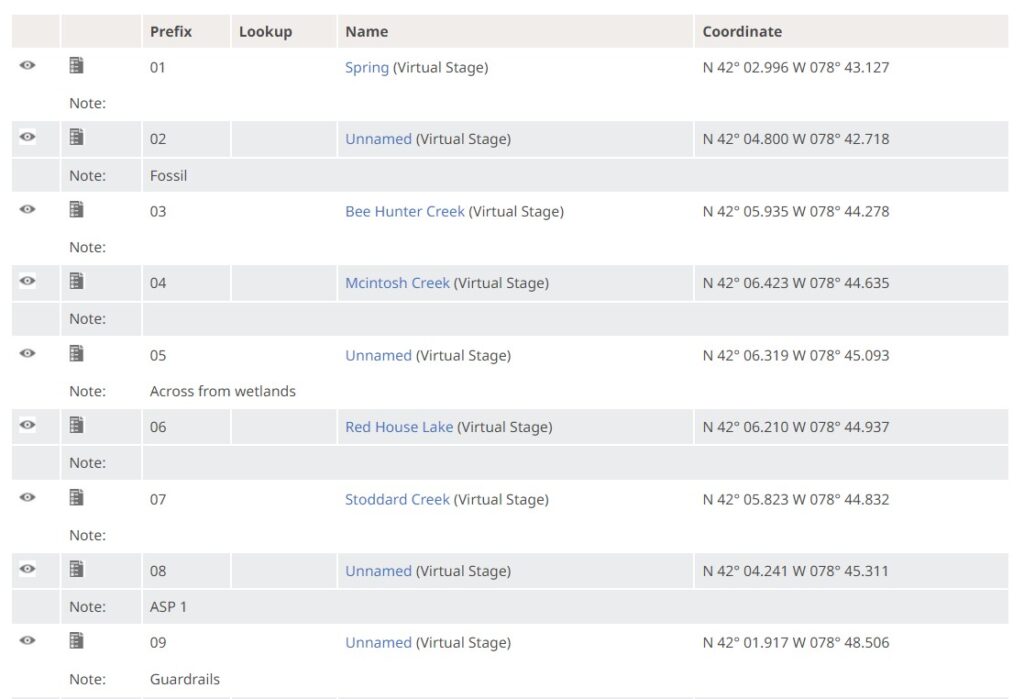
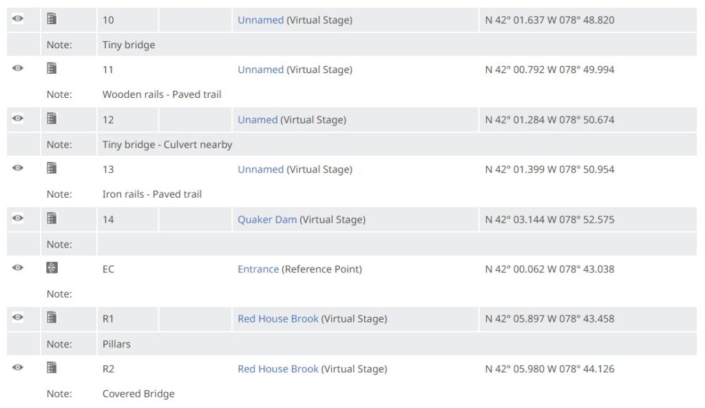
Waypoints 1-16 … 1 (Spring) / 2 (Fossil) / 3 Bee Hunter Creek / 4 Mcintosh Creek / 5 (Wetlands) / 6 Red House Lake – riprap along the banks / 7 Stoddard Creek / 8 (ASP 1) / 9 (Guardrails) / 10 (Tiny Bridge) / 11 (Wooden Rails) / 12 (Culvert Nearby) / 13 (Iron Rails) / 14 Quaker Dam – reinforced concrete walls along the dam and spillway / There are no erosion control methods on any of the brooks/creeks/streams probably because they do not impact any developmental features in the park.
Waypoints R1 and R2 – R1 Red House Brook has arches and pillars / R2 Red House Brook 2 has a covered bridge
11a. Waypoint 1 – You can hear the spring, but cannot see it because it has a curved rock structure covering it
11b. Waypoint R1 R2 Red House Brook – Only Bigfoot could step across this fairly large span of water
REVIEWER NOTES
Thank you for your EarthCache submission. A few adjustments are required to bring the EarthCache into compliance with the EarthCache guidelines posted at http://www.geosociety.org/GSA/fieldexp/EarthCache/guidelines/home.aspx. Additional information may be found in the Groundspeak Knowledge Books at https://www.geocaching.com/help/index.php?pg=kb.chapter&id=51.
What is the Earth Science lesson you want to teach with this EarthCache? On the surface, the EarthCache page appears to be a multi-stage virtual cache. The text body is about stream banks and their shapes. The logging tasks are about what type of man-made structures are present for erosion control. What is special about the locations that do not have man-made erosion control features? Recommend making a better connection between the Earth Science lesson and the logging tasks.
This outline may help focus the effort: 1) Select the earth science lesson to teach; 2) Develop cache page content that teaches the selected earth science lesson; and 3) Develop corresponding logging tasks that provide proof of learning the desired lesson.